


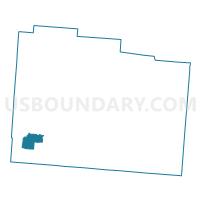
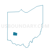
PRECINCT SUGARCREEK 154, Greene County, Ohio
About
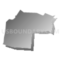
Outline

Summary
| Unique Area Identifier | 646804 |
| Name | PRECINCT SUGARCREEK 154 |
| County | Greene County |
| State | Ohio |
| Area (square miles) | 4.02 |
| Land Area (square miles) | 3.99 |
| Water Area (square miles) | 0.03 |
| % of Land Area | 99.25 |
| % of Water Area | 0.75 |
| Latitude of the Internal Point | 39.61506560 |
| Longtitude of the Internal Point | -84.06411630 |
Maps

Graphs
Select a template below for downloading or customizing gragh for PRECINCT SUGARCREEK 154, Greene County, Ohio


Neighbors
Neighoring Voting District (by Name) Neighboring Voting District on the Map
- PRECINCT BELLBROOK 102, Greene County, OH
- PRECINCT BELLBROOK 103, Greene County, OH
- PRECINCT SPG VLY TWP 435, Greene County, OH
- PRECINCT SPG VLY TWP 436, Greene County, OH
- PRECINCT SUGARCREEK 153, Greene County, OH
- PRECINCT SUGARCREEK 155, Greene County, OH
Top 10 Neighboring County Subdivision (by Population) Neighboring County Subdivision on the Map
- Sugarcreek township, Greene County, OH (8,041)
- Bellbrook city, Greene County, OH (6,943)
- Spring Valley township, Greene County, OH (2,581)
Top 10 Neighboring Place (by Population) Neighboring Place on the Map
Top 10 Neighboring Unified School District (by Population) Neighboring Unified School District on the Map
Top 10 Neighboring State Legislative District Lower Chamber (by Population) Neighboring State Legislative District Lower Chamber on the Map
Top 10 Neighboring State Legislative District Upper Chamber (by Population) Neighboring State Legislative District Upper Chamber on the Map
Top 10 Neighboring 111th Congressional District (by Population) Neighboring 111th Congressional District on the Map
Top 10 Neighboring Census Tract (by Population) Neighboring Census Tract on the Map
- Census Tract 2201, Greene County, OH (7,698)
- Census Tract 2202, Greene County, OH (7,553)
- Census Tract 2301, Greene County, OH (2,577)